Intact forest landscapes
Mapping the last remaining large untouched forests
2025
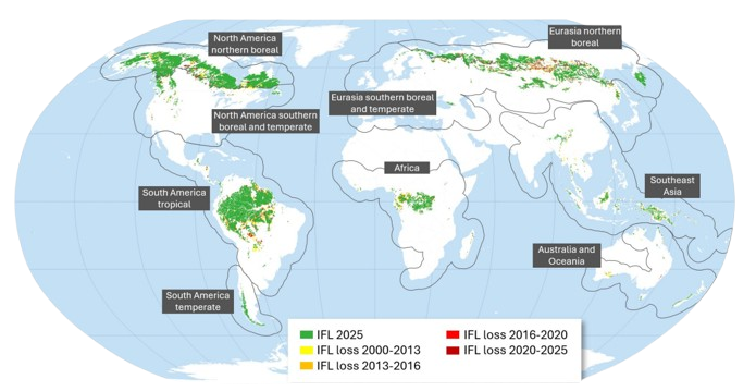
The latest global IFL map update, representing the IFL extent as of January 1, 2025, has been completed by the IFL Mapping Team. The IFL Mapping Team includes specialists from the World Resources Institute, Global Land Analysis and Discovery lab at the University of Maryland, and Greenpeace International Global Mapping Hub. The IFL update was done by volunteers and was not directly funded by any organization or donor.
The 2000-2025 Intact Forest Landscapes Extent and Change report has been prepared by the group of researchers from different organizations. The report summarizes the IFL change over the past quarter century, provides the analysis of IFL loss drivers, and predicts the future IFL area change.
The IFL 2000, 2013, 2016, 2020, and 2025 layers were converted to the GeoPackage format and are available here.
2022
The carbon estimation in IFL for the year 2020 produced. The results show 40 Gt of carbon dioxide are stored within IFL extent
2021
The updated IFL map for the year 2020 released. The extent of the world's intact forest landscapes decreased by 12% (155 million hectares) between 2000 and 2020
2017
The paper “The last frontiers of wilderness: Tracking loss of intact forest landscapes from 2000 to 2013” released. The global IFL extent has been reduced by 7.2% since the year 2000
The updated IFL map for 2016 released
2014
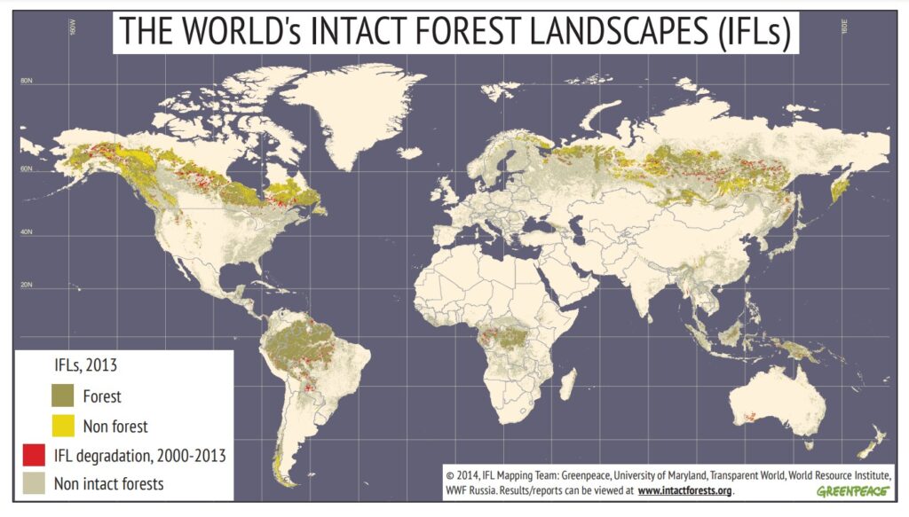
The map of IFL degradation for the year 2013 released in collaboration with the University of Maryland and WWF Russia. 8% of these wilderness areas had been degraded since 2000
2013
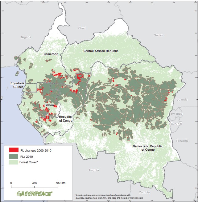
The paper “Satellite-based primary forest degradation assessment in the Democratic Republic of the Congo, 2000–2010” released. From 2000 to 2010, 1.02% of primary forest cover was lost due to clearing, and almost 2% were degraded due to alteration and fragmentation
2011
The report “Intact Forest Landscapes: Why it is crucial to protect them from industrial exploitation” released
The report “Intact Forest Landscapes: Why it is crucial to protect them from industrial exploitation. Case Study: The Congo” released
2008
The first IFL paper “Mapping the World’s Intact Forest Landscapes by Remote Sensing” in an international peer review journal released. This paper introduces a new approach for mapping large intact forest landscapes. The global area of IFL within the forest ecosystems in 2000 is 13.1 million km2 or 23.5% of the forest zone. The vast majority of IFL are found in two biomes: Dense Tropical and Subtropical Forests (45.3%) and Boreal Forests (43.8%)
2006
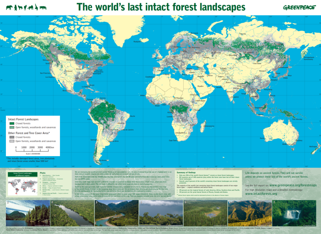
The international mapping project led by Greenpeace with contributions from Transparent World, WRI and other NGOs and institutions proposed identifying and mapping the location and health of the world’s last remaining large intact forests
The first global IFL map for the year 2000 released
The “Roadmap to Recovery: The World's Last Intact Forest Landscapes” report released
2004
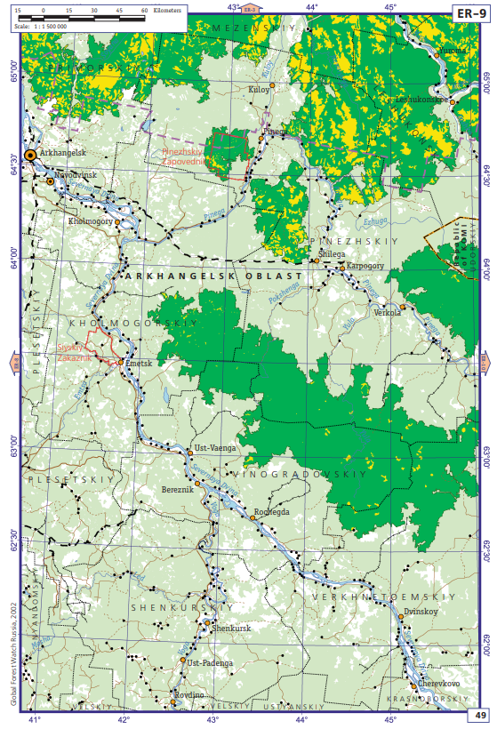
The very first methodology of IFL delineation was developed and published for Northern European part of Russia
The Atlas of Russian IFLs published followed by expanding and adapting the methodology for the whole global boreal region